


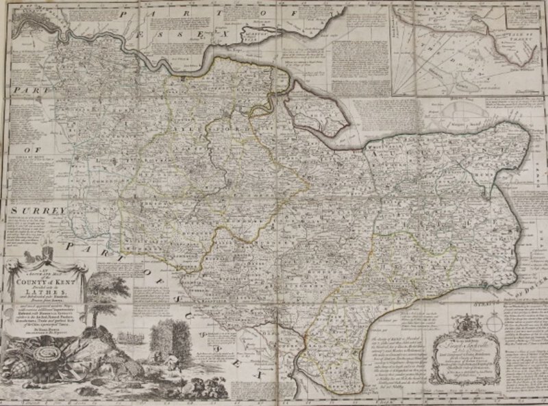


AN ACCURATE MAP OF THE COUNTY OF KENT DIVIDED INTO ITS LATHES, and Subdivided into Hundreds. Drawn from Surveys, and most approved modern Maps, with various additional Improvements : Illustrated with Historical Extracts relative to the Air, Soil, Natural Produce, Manufactures, Trade and present State of its Cities & principal Towns.
London: Printed for Rt. Wilkinson, in Cornhill, Carington Bowles in St. Paul's & Robt. Sayer In Fleet Street, No date [circa 1760's]. Copper line engraving on paper, with original outline hand-colour. 540 x 725mm (approx. 21" x 28.5"). Dissected into 16, and mounted on linen. Folding into the original marbled slip-case, with the engraved labels of Robert Sayer, opposite Fetter Lane, Fleet Street, and S. Neele, near Exeter Change Strand. Case lightly rubbed and worn; else a very good, clean copy of this large and handsome map of Kent compiled by Emanuel Bowen, Geographer to George II, and originally produced in 1751 for a series of maps separately sold from 1749 on and eventually published as "The Large English Atlas" (London 1760). Borders filled with the numerous historical and geographical information concerning individual towns etc. Inset Chart of the Goodwin Sands. Engraved pictorial title cartouche showing the principal trades and produce of the County: ship-building, fishing, hops and fruit. Engraved dedication panel to Lionel Sackville, Duke of Dorset, Lord Lieutenant & Custos Rotulorum for the County of Kent, etc.