- Tag = Maps
-
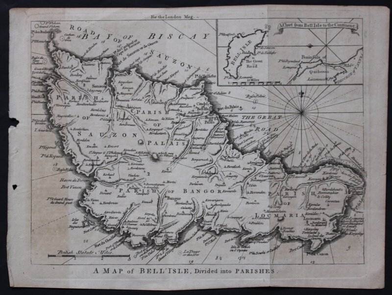
 A MAP OF BELL' ISLE, Divided into Parishes.
An engraved map, uncoloured as issued, commissioned for the London Magazine, 1761, measuring 21 x 28 cm. Two vertical crease-marks where once folded into the book, else fine.
More details Price: £75.00 -
![A MAP OF THE ISLE OF THANET. Published by J. Hall, Bookseller Margate. by HALL, J[ohn].](https://images.vialibri.net/production/21/12426---200.jpg?v=1578942522) A MAP OF THE ISLE OF THANET. Published by J. Hall, Bookseller Margate.
More details Price: £375.00
A MAP OF THE ISLE OF THANET. Published by J. Hall, Bookseller Margate.
More details Price: £375.00 -
![A MAP OF THE KINGDOM OF IRELAND from ye latest & best Observations. For Mr Tindal's Continuation of Mr. Rapin's History [of England].](https://images.vialibri.net/production/21/12530---200.jpg?v=1578945201) A MAP OF THE KINGDOM OF IRELAND from ye latest & best Observations. For Mr Tindal's Continuation of Mr. Rapin's History [of England].
A MAP OF THE KINGDOM OF IRELAND from ye latest & best Observations. For Mr Tindal's Continuation of Mr. Rapin's History [of England].
Cartographer: Richard William Seale, No date (circa 1751). An engraved map, uncoloured as issued. Sheet size: 495 x 420mm (191/2 x 161/2). Trimmed very close at the bottom left-hand corner where cut for folding into the book, with some creasing and two short tears. Else a very fine impression with original binding folds.
More details Price: £90.00 -
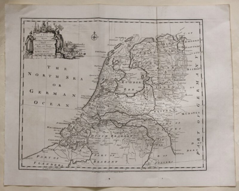
 A New and Correct Map of the Seven UNITED PROVINCES Drawn from the most approved Maps and Charts: The whole being regulated by Astronomical Observations. By Eman. Bowen. For Mr Tindal's Continuation of Mr Rapin's History of England.
Circa 1751. Engraved map, uncoloured as issued. Sheet size: 413 x 515 mm (161/4" x 201/4"). Very fine impression with original binding folds.
More details Price: £55.00 -
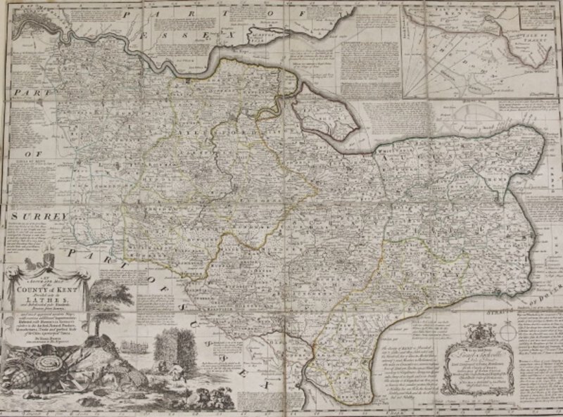
 AN ACCURATE MAP OF THE COUNTY OF KENT DIVIDED INTO ITS LATHES, and Subdivided into Hundreds. Drawn from Surveys, and most approved modern Maps, with various additional Improvements : Illustrated with Historical Extracts relative to the Air, Soil, Natural Produce, Manufactures, Trade and present State of its Cities & principal Towns.
More details Price: £500.00
AN ACCURATE MAP OF THE COUNTY OF KENT DIVIDED INTO ITS LATHES, and Subdivided into Hundreds. Drawn from Surveys, and most approved modern Maps, with various additional Improvements : Illustrated with Historical Extracts relative to the Air, Soil, Natural Produce, Manufactures, Trade and present State of its Cities & principal Towns.
More details Price: £500.00 -
BALTIC SEA by John Tallis.
An antique steel-engraved map issued circa1858 by the London Printing and Publishing Co. Reverse blank. Centre fold as issued. Outlined coloured as issued. Paper Size: 26.8 x 35 cm. A very clean example.
More details Price: £35.00 -
BLACK SEA by John Tallis.
An antique steel-engraved map issued circa1858 by the London Printing and Publishing Co. Reverse blank. Centre fold as issued. Outlined coloured as issued. Paper Size: 26.8 x 35 cm. A very clean example.
More details Price: £35.00 -
![CHART of the N W COAST of AMERICA and N E COAST of ASIA explored in the Years 1778 & 1779. The ushaded parts of the Coast of Asia are taken from a M S Chart received from the Russians. Writing engraved by T. Harmer. [Copied by Lieut. Henry Roberts.]](https://images.vialibri.net/production/21/12147---200.jpg?v=1578775045) CHART of the N W COAST of AMERICA and N E COAST of ASIA explored in the Years 1778 & 1779. The ushaded parts of the Coast of Asia are taken from a M S Chart received from the Russians. Writing engraved by T. Harmer. [Copied by Lieut. Henry Roberts.]
CHART of the N W COAST of AMERICA and N E COAST of ASIA explored in the Years 1778 & 1779. The ushaded parts of the Coast of Asia are taken from a M S Chart received from the Russians. Writing engraved by T. Harmer. [Copied by Lieut. Henry Roberts.]
[1784.]. Sheet size: 55 x 76 cm. Plate mark: 42.2 x 69 cm. Uncoloured as issued. Centrefold as issue in the Atlas volume of Cook, James. A Voyage to the Pacific Ocean. Undertaken, by the Command of His Majesty, for Making Discoveries in the Northern Hemisphere, to Determine the Position and Extent of the West Side of North America; Its Distance from Asia; and the Practicability of a Northern Passage to Europe. Performed under the Direction of Captains Cook, Clerke, and Gore, in His Majesty’s Ships the Resolution and Discovery, in the Years 1776, 1777, 1778, 1779, and 1780. Published 1784. An excellent example with wide margins.
More details Price: £750.00 -
CUMBERLAND.
Copperplate engraving sold by Abel Swale Awnsham & Jon Churchill. No date [circa 1722]. Sheet size: 39 x 45 cm. Printed image: 36.2 x 41.8 cm. Uncoloured as issued. Folded at centre as presented in William
More details Price: £75.00 -
 East Africa Protectorate. NAKURU-NYERI
1913. Sheet South A-37. Folding linen-backed map issued by Sifton, Praed & Co. Ltd. No date, but map Drawn and printed at the War Office, March, 1913. 65 x 54 cm. Excellent condition.
More details Price: £50.00 -
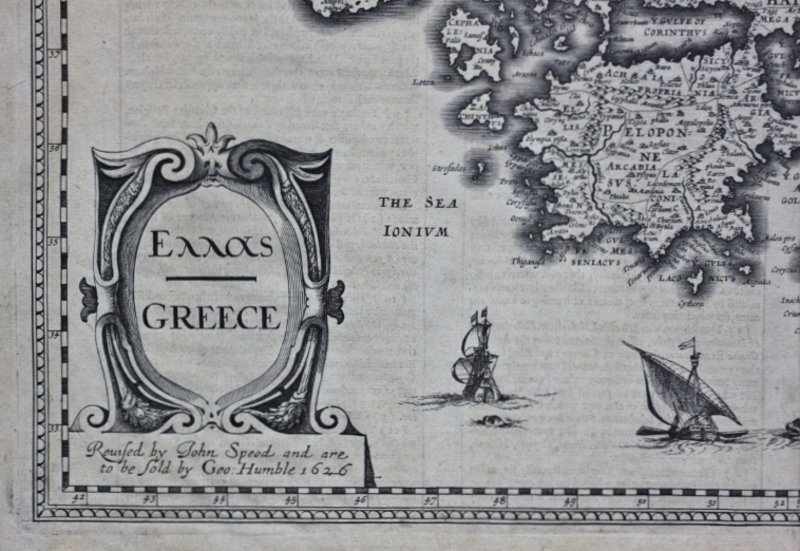
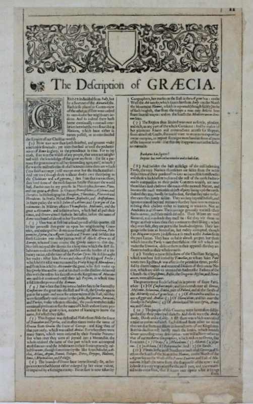
 GREECE. Reissued by John Speed and are to be sold by Geo. Humble.
1626. Map of Greece, possibly 1651, uncoloured; English text to the reverse. 42 x 54 cm. Edges and centrefold strengthened on the verso; slight browning to edges; short tear in lower blank margin [no loss]; else a very good copy.
More details Price: £550.00 -
HISTORY OF CARTOGRAPHY Revised and enlarged by R. A. Skelton Superintendent of the Map Room at the British Museum.
London.C. A. Watts & Co. Ltd. 1964. 312pp. Illustrated throughout in colour and black & white. Original pictorial cloth gilt. Pictorial dust-wrapper. Quarto. First edition thus. Dust-wrapper a little chipped at head of spine; else a very good copy.
More details Price: £55.00 -
 Kenya Colony. UASIN GISHU.
1913. Sheet North A-36. Folding linen-backed map issued by Sifton, Praed & Co. Ltd. No date, but map Drawn and printed at the War Office, March, 1913. Revised and reprinted, July 1925. 65 x 54 cm. Excellent condition.
More details Price: £50.00 -
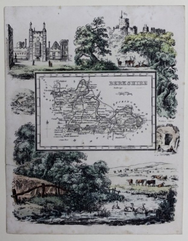
 Map of Berkshire.
Darton and Clark, No date. [circa 1844]. Map of Berkshire, taken from Rueben Ramble's travels through the counties of England, published by Darton and Clark, circa 1844, a work intended for children. A hand-coloured lithograph, as issued, measuring approximately 20.5 x 16 cm. The map within the pictorial framework is uncoloured, as issued. Few light marks at very top & bottom on sheet; else very good.
More details Price: £60.00 -
 Map of Cornwall.
Darton and Clark, No date. [circa 1844]. Map of Cornwall, taken from Rueben Ramble's travels through the counties of England, published by Darton and Clark, circa 1844, a work intended for children. A hand-coloured lithograph, as issued, measuring approximately 20.5 x 16 cm. The map within the pictorial framework is coloured green. Couple of light marks, else very good.
More details Price: £60.00 -
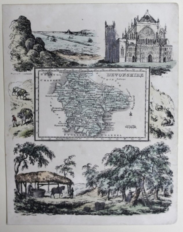
 Map of Devonshire.
Darton and Clark, No date. [circa 1844]. Map of Devonshire, taken from Rueben Ramble's travels through the counties of England, published by Darton and Clark, circa 1844, a work intended for children. A hand-coloured lithograph, as issued, measuring approximately 20.5 x 16 cm. The map within the pictorial framework is uncoloured, as issued.
More details Price: £60.00 -
![Map of Gloucestsh.[ire].](https://images.vialibri.net/production/21/9391---200.jpg?v=1530302723) Map of Gloucestsh.[ire].
Map of Gloucestsh.[ire].
Darton and Clark, No date. [circa 1844]. Map of Gloucestsh.[ire], taken from Rueben Ramble's travels through the counties of England, published by Darton and Clark, circa 1844, a work intended for children. A hand-coloured lithograph, as issued, measuring approximately 20.5 x 16 cm. The map within the pictorial framework is uncoloured, as issued.
More details Price: £60.00 -
 Map of Hampshire.
Darton and Clark, No date. [circa 1844]. Map of Hampshire, taken from Rueben Ramble's travels through the counties of England, published by Darton and Clark, circa 1844, a work intended for children. A hand-coloured lithograph, as issued, measuring approximately 20.5 x 16 cm. The map within the pictorial framework is uncoloured, as issued.
More details Price: £60.00 -
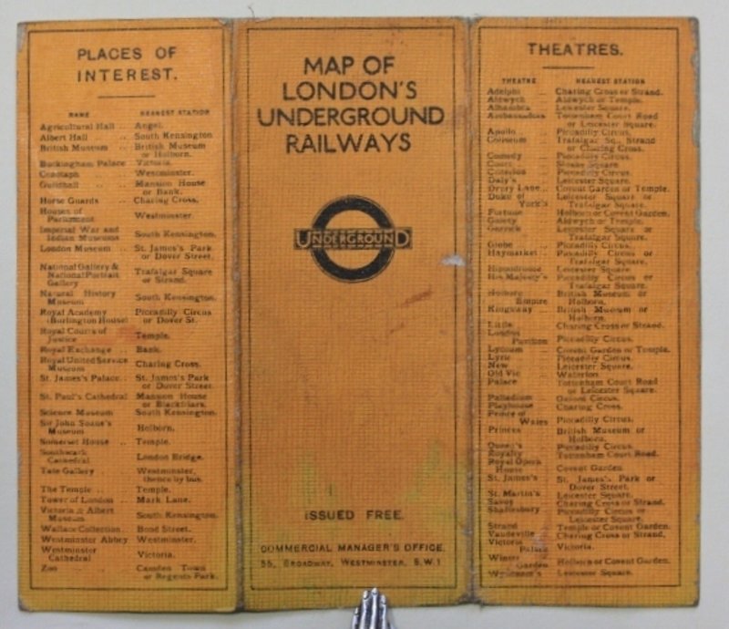
 MAP OF LONDON'S UNDERGROUND RAILWAYS. Issued Free.
Commercial Manager's Office.55, Broadway. Westminster. S.W.1, June 1927. Folding coloured map mounted on linen. Cover/Title, Theatres, Places of Interest, on one side; map on other. Unfolded: 12.7 x 14.7. Little worn; little browned at folds; short closed tear; else very good.
More details Price: £100.00 -
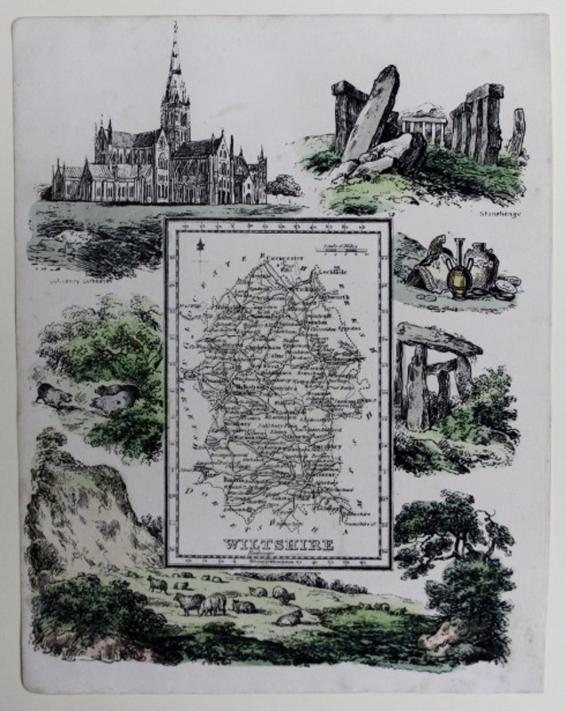
 Map of Wiltshire.
Darton and Clark, No date. [circa 1844]. Map of Wiltshire, taken from, Rueben Ramble's Travels through the Counties of England, published by Darton and Clark, circa 1844, a work intended for children. A hand-coloured lithograph, as issued, measuring approximately 20.5 x 16 cm. The map within the pictorial framework is uncoloured, as issued.
More details Price: £60.00
![A MAP OF THE ISLE OF THANET. Published by J. Hall, Bookseller Margate. by HALL, J[ohn].](https://images.vialibri.net/production/21/12426---800.jpg?v=1578942522)
![Another image of A MAP OF THE ISLE OF THANET. Published by J. Hall, Bookseller Margate. by HALL, J[ohn].](https://images.vialibri.net/production/21/12426_1---800.jpg?v=1578942523)
![Another image of A MAP OF THE ISLE OF THANET. Published by J. Hall, Bookseller Margate. by HALL, J[ohn].](https://images.vialibri.net/production/21/12426_2---800.jpg?v=1578942523)
![Another image of A MAP OF THE ISLE OF THANET. Published by J. Hall, Bookseller Margate. by HALL, J[ohn].](https://images.vialibri.net/production/21/12426_3---800.jpg?v=1578942524)
![Another image of A MAP OF THE ISLE OF THANET. Published by J. Hall, Bookseller Margate. by HALL, J[ohn].](https://images.vialibri.net/production/21/12426_4---800.jpg?v=1578942524)
![A MAP OF THE KINGDOM OF IRELAND from ye latest & best Observations. For Mr Tindal's Continuation of Mr. Rapin's History [of England].](https://images.vialibri.net/production/21/12530---800.jpg?v=1578945201)
![Another image of A MAP OF THE KINGDOM OF IRELAND from ye latest & best Observations. For Mr Tindal's Continuation of Mr. Rapin's History [of England].](https://images.vialibri.net/production/21/12530_1---800.jpg?v=1578945201)
![Another image of A MAP OF THE KINGDOM OF IRELAND from ye latest & best Observations. For Mr Tindal's Continuation of Mr. Rapin's History [of England].](https://images.vialibri.net/production/21/12530_2---800.jpg?v=1578945202)


![CHART of the N W COAST of AMERICA and N E COAST of ASIA explored in the Years 1778 & 1779. The ushaded parts of the Coast of Asia are taken from a M S Chart received from the Russians. Writing engraved by T. Harmer. [Copied by Lieut. Henry Roberts.]](https://images.vialibri.net/production/21/12147---800.jpg?v=1578775045)
![Another image of CHART of the N W COAST of AMERICA and N E COAST of ASIA explored in the Years 1778 & 1779. The ushaded parts of the Coast of Asia are taken from a M S Chart received from the Russians. Writing engraved by T. Harmer. [Copied by Lieut. Henry Roberts.]](https://images.vialibri.net/production/21/12147_1---800.jpg?v=1578775045)
![Another image of CHART of the N W COAST of AMERICA and N E COAST of ASIA explored in the Years 1778 & 1779. The ushaded parts of the Coast of Asia are taken from a M S Chart received from the Russians. Writing engraved by T. Harmer. [Copied by Lieut. Henry Roberts.]](https://images.vialibri.net/production/21/12147_2---800.jpg?v=1578775044)


![Map of Gloucestsh.[ire].](https://images.vialibri.net/production/21/9391---800.jpg?v=1530302723)