- Tag = Ephemera, Maps, Original Art, Prints
-
 A carte-de-visite.
London: No date [circa 1860s]. A carte-de-visite by Elliott & Fry of 56 Baker, Portman Square, London, of the novelist Anthony Trollope. 10.2 x 6.2 cm. Library stamp on verso, little faded, else very good.
More details Price: £75.00 -
![A four page letter. by [EWING, Juliana Horatio.]](https://images.vialibri.net/production/21/12447---200.jpg?v=1578943464) A four page letter.
A four page letter.
Dated 3rd July 1884 signed in full, addressed from Villa Ponent, Taunton, Sheffield to an unknown correspondent, concerning a request for permission to use excerpts from Juliana's and her mother's books for a children's reading book. She makes clear that her consent will be forthcoming upon receipt of a list, but suggests that her Father be contacted at Ecclesfield Vicarage, Sheffield, to obtain permission to include excerpts from her mother's book. Fine condition.
More details Price: £90.00 -
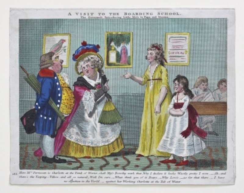
 A hand-coloured engraved cartoon entitled, 'A Visit to the Boarding School'.
No publisher or date, but circa 1825. The engraving pokes fun at the ignorance of the aspiring parents of Miss Dorothy, who has recently been admitted to a school for young ladies, by recourse to a play on words: The tomb of Werter/ The tub of water. There is a printed number, 183 in the extreme left-hand corner which would suggest that this is part of a series. 20 x 25 cm's. Trimmed to platemark; evidence of removal from an album on blank verso; else very good.
More details Price: £35.00 -
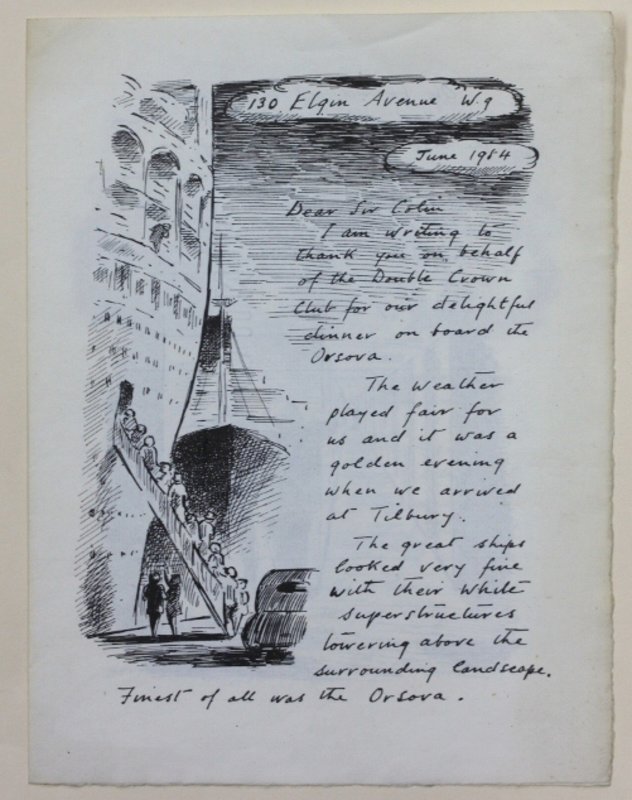
 A letter to the Double Crown Club, thanking them for a dinner given on board the Orsova 1954.
1954. A four-page lithographed reprint of a letter from Ardizzone, illustrated with line drawings. Page size: 22 x 16.5 cm. A fine copy of a very scarce item.
More details Price: £175.00 -
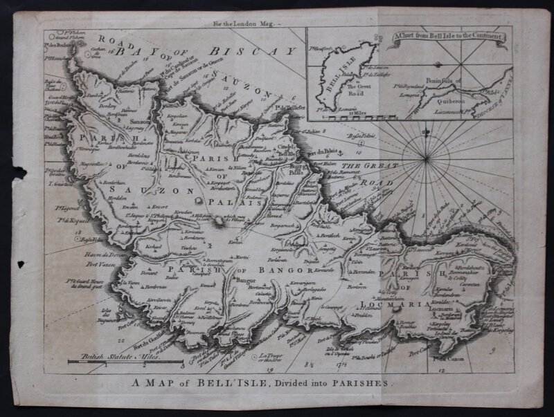
 A MAP OF BELL' ISLE, Divided into Parishes.
An engraved map, uncoloured as issued, commissioned for the London Magazine, 1761, measuring 21 x 28 cm. Two vertical crease-marks where once folded into the book, else fine.
More details Price: £75.00 -
![A MAP OF THE ISLE OF THANET. Published by J. Hall, Bookseller Margate. by HALL, J[ohn].](https://images.vialibri.net/production/21/12426---200.jpg?v=1578942522) A MAP OF THE ISLE OF THANET. Published by J. Hall, Bookseller Margate.
More details Price: £375.00
A MAP OF THE ISLE OF THANET. Published by J. Hall, Bookseller Margate.
More details Price: £375.00 -
![A MAP OF THE KINGDOM OF IRELAND from ye latest & best Observations. For Mr Tindal's Continuation of Mr. Rapin's History [of England].](https://images.vialibri.net/production/21/12530---200.jpg?v=1578945201) A MAP OF THE KINGDOM OF IRELAND from ye latest & best Observations. For Mr Tindal's Continuation of Mr. Rapin's History [of England].
A MAP OF THE KINGDOM OF IRELAND from ye latest & best Observations. For Mr Tindal's Continuation of Mr. Rapin's History [of England].
Cartographer: Richard William Seale, No date (circa 1751). An engraved map, uncoloured as issued. Sheet size: 495 x 420mm (191/2 x 161/2). Trimmed very close at the bottom left-hand corner where cut for folding into the book, with some creasing and two short tears. Else a very fine impression with original binding folds.
More details Price: £90.00 -
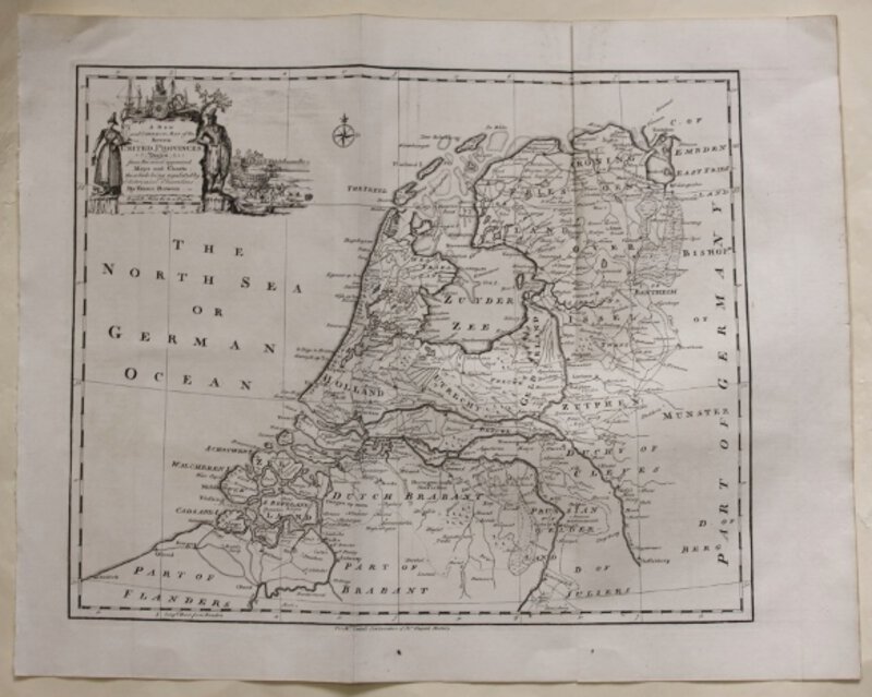
 A New and Correct Map of the Seven UNITED PROVINCES Drawn from the most approved Maps and Charts: The whole being regulated by Astronomical Observations. By Eman. Bowen. For Mr Tindal's Continuation of Mr Rapin's History of England.
Circa 1751. Engraved map, uncoloured as issued. Sheet size: 413 x 515 mm (161/4" x 201/4"). Very fine impression with original binding folds.
More details Price: £55.00 -
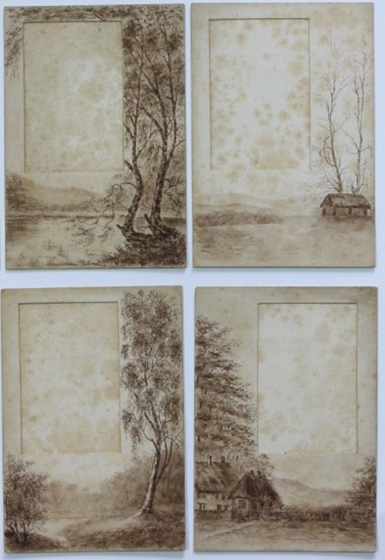
 A part set of nine home-made menu display cards
A part set of nine home-made menu display cards, decorated with watercolours of rural scenes. Circa late Victorian / early Edwardian. Each card: 17.3 x 12 cm. Each is made in such a way that a slip of paper with the written menu may be placed inside and displayed in a 'window.' Some spotting, particularly in the 'windows;' three cards lack their 'legs;' but still very nice.
More details Price: £45.00 -
 A printed 'Account' of the Charity-School at Worfield
1817. A printed 'Account' of the Charity-School at Worfield [Shropshire], for the year March 1817 to March 1818. Small hole in centre of the sheet, not affecting the printing; else in excellent condition. 25.5 x 19.7 cms.
More details Price: £35.00 -
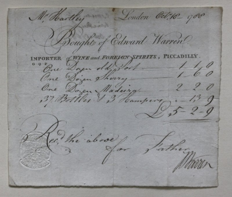
 A printed bill from Edward Warren, importer of wine and foreign spirits...
More details Price: £50.00
A printed bill from Edward Warren, importer of wine and foreign spirits...
More details Price: £50.00 -
 A set of 8 gilt-edged place-setting cards
A set of 8 gilt-edged place-setting cards, painted in watercolour with wild flowers. Circa late Victorian / early Edwardian. Each card, oblong: 4.9 x 8.5 cm. Some spotting; some light wear; else very good. All retain names from the last time they were used.
More details Price: £30.00 -
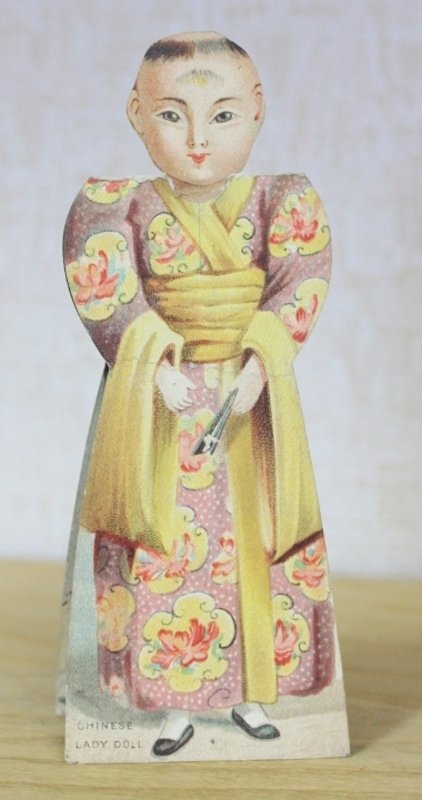
 A shaped die-cut reversible paper doll. Making: 'A Jap Boy Dolly; A Chinese Lady Doll; Jap Lady Dolly; Chinese boy Doll.
No date or imprint; probably German, circa 1890. Maximum size: 14 x 5.5 cm. Neck at one joint crease; crease in one side; else very good.
More details Price: £45.00 -
 Act of Parliament.
1884. An Act for incorporating the Chatham and Brompton Tramways Company and empowering them to construct Street Tramways in the parishes of Chatham and Gillingham in the county of Kent and for other purposes. [7th August 1884.] Sessional number [Local.-234.] 27 pages. Together with: An Act For the abandonment of the Chatham and Brompton Tramways and for Authorising the Release of the Deposit Fund remaining deposited as security for the completion thereof. 1888. Title and three pages. Both in very good condition. Sold as a pair.
More details Price: £40.00 -
 An A.L.S from Mary Cholmondeley to Lady Victoria, dated June 9th 1900, written on 'Tolmers' headed paper, accepting an invitation to luncheon.
1900. Seven lines. Crease where folded, else very good. Mary Cholmondeley (8 June 1859 – 15 July 1925) was an English writer, whose novel Red Potage was huge success on both sides of the Atlantic in 1899. Lady Victoria Alexandrina Mary Cecil Herbert was the third daughter of Henry Howard Molyneux Herbert,. the 4th Earl of Carnarvon. Her mother was Lady Evelyn Georgina Katherine Herbert (nee Stanhope), daughter of the 6th Earl of Chesterfield.
More details Price: £60.00 -
![An A.L.S. from Mary Clare to Dolly Harding [ Dolores].](https://images.vialibri.net/production/21/10541---200.jpg?v=1530131421) An A.L.S. from Mary Clare to Dolly Harding [ Dolores].
An A.L.S. from Mary Clare to Dolly Harding [ Dolores].
Written from the Globe Theatre, December 5th 1927, discussing a play that Harding had sent her to read, and arranging a meeting. Written on two pages of four. Very good. Mary Clare (17 July 1892 - 29 August 1970) was a British actress who performed in films, on the stage and later on television.
More details Price: £20.00 -
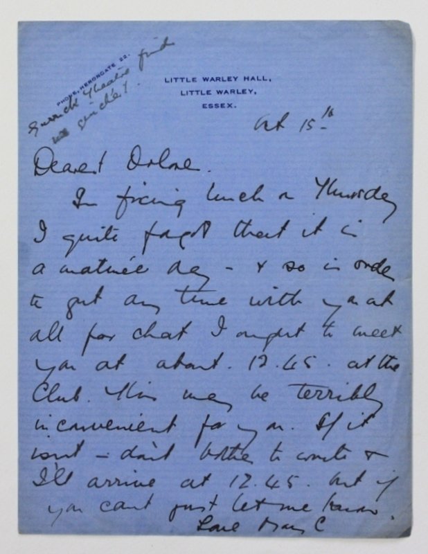
 An A.L.S. from Mary Clare to Dolores Harding
1892. Written from Little Warley Hall, Little Warley, Essex, dated Oct 15th, rearranging a date of a meeting between the two. Written on a single side. Very good. Mary Clare (17 July 1892 - 29 August 1970) was a British actress who performed in films, on the stage and later on television.
More details Price: £15.00 -
 An A.L.S. from the actor Charles Warner To Count Max Hollender.
Dated 1904, requesting a meeting at the Palace Theatre, London. Written on two sides of four pages, on Green Room Club headed paper. Charles Lickfold Warner (10 October 1846 – 12 February 1909), was an English actor born in Kensington. He first appeared in 1861 at a special performance of Richelieu before Queen Victoria. He committed suicide by hanging himself in his hotel room at the age of 63.
More details Price: £25.00 -
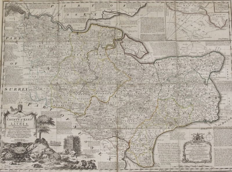
 AN ACCURATE MAP OF THE COUNTY OF KENT DIVIDED INTO ITS LATHES, and Subdivided into Hundreds. Drawn from Surveys, and most approved modern Maps, with various additional Improvements : Illustrated with Historical Extracts relative to the Air, Soil, Natural Produce, Manufactures, Trade and present State of its Cities & principal Towns.
More details Price: £500.00
AN ACCURATE MAP OF THE COUNTY OF KENT DIVIDED INTO ITS LATHES, and Subdivided into Hundreds. Drawn from Surveys, and most approved modern Maps, with various additional Improvements : Illustrated with Historical Extracts relative to the Air, Soil, Natural Produce, Manufactures, Trade and present State of its Cities & principal Towns.
More details Price: £500.00 -
 An Act for erecting a Workhouse in the City of Canterbury, for imploying and maintaining the Poor there, and for better enlightening the Streets of the said City.
London: John Baskett, Printer to the King's most Excellent Majesty, 1728. General title followed by pages 619 – 639, complete. 29 x 19.5 cm. Disbound from a collection of Acts, with evidence of such to the spine. A very good copy.
More details Price: £45.00


![A four page letter. by [EWING, Juliana Horatio.]](https://images.vialibri.net/production/21/12447---800.jpg?v=1578943464)
![Another image of A four page letter. by [EWING, Juliana Horatio.]](https://images.vialibri.net/production/21/12447_1---800.jpg?v=1578943465)
![Another image of A four page letter. by [EWING, Juliana Horatio.]](https://images.vialibri.net/production/21/12447_2---800.jpg?v=1578943465)

![A MAP OF THE ISLE OF THANET. Published by J. Hall, Bookseller Margate. by HALL, J[ohn].](https://images.vialibri.net/production/21/12426---800.jpg?v=1578942522)
![Another image of A MAP OF THE ISLE OF THANET. Published by J. Hall, Bookseller Margate. by HALL, J[ohn].](https://images.vialibri.net/production/21/12426_1---800.jpg?v=1578942523)
![Another image of A MAP OF THE ISLE OF THANET. Published by J. Hall, Bookseller Margate. by HALL, J[ohn].](https://images.vialibri.net/production/21/12426_2---800.jpg?v=1578942523)
![Another image of A MAP OF THE ISLE OF THANET. Published by J. Hall, Bookseller Margate. by HALL, J[ohn].](https://images.vialibri.net/production/21/12426_3---800.jpg?v=1578942524)
![Another image of A MAP OF THE ISLE OF THANET. Published by J. Hall, Bookseller Margate. by HALL, J[ohn].](https://images.vialibri.net/production/21/12426_4---800.jpg?v=1578942524)
![A MAP OF THE KINGDOM OF IRELAND from ye latest & best Observations. For Mr Tindal's Continuation of Mr. Rapin's History [of England].](https://images.vialibri.net/production/21/12530---800.jpg?v=1578945201)
![Another image of A MAP OF THE KINGDOM OF IRELAND from ye latest & best Observations. For Mr Tindal's Continuation of Mr. Rapin's History [of England].](https://images.vialibri.net/production/21/12530_1---800.jpg?v=1578945201)
![Another image of A MAP OF THE KINGDOM OF IRELAND from ye latest & best Observations. For Mr Tindal's Continuation of Mr. Rapin's History [of England].](https://images.vialibri.net/production/21/12530_2---800.jpg?v=1578945202)


![An A.L.S. from Mary Clare to Dolly Harding [ Dolores].](https://images.vialibri.net/production/21/10541---800.jpg?v=1530131421)
![Another image of An A.L.S. from Mary Clare to Dolly Harding [ Dolores].](https://images.vialibri.net/production/21/10541_1---800.jpg?v=1530131353)